Detail of Madrid Codex
  1. Madrid Codex

    The Madrid Codex appears here as an exemplar of a Mesoamerican codex. The original manuscript is typical in that it is painted on both sides of a paper made from fig tree bark, with the individual leaves assembled in an accordion format. The Madrid contains a rich record of divination and astrology. This is one of two sections that compose the complete codex, which were originally found as separate manuscripts.

Maya City of Palenque
  1. The Maya City of Palenque (from Splendours)

    Mesoamerica extends through a wide variety of geographic and climatic zones, from high desert to dense jungle. The Maya city of Palenque, located deep in the rain forest in the northeast of the state of Chiapas, was reclaimed from the jungle, which is ever encroaching just beyond the ruins.

Map of Mesoamerica
  1. Map of Mesoamerica (from Splendours)

    This map of the Mesoamerican region shows the locations of the most important cities and historical sites that have been discovered to date, many of which are represented by materials in this exhibit. The expanse of Maya and Aztec influence is clearly shown (red shading for the Aztec area at left, green shading for the Maya area at right).

The City of Teotihuacán
  1. The City of Teotihuacán (from Teotihuacán)

    The landscape surrounding the great city of Teotihuacán in central Mexico is in sharp contrast to that of Palenque. Teotihuacán pre-dates the Aztec empire, but lies within the territory later held by the Aztecs (it is located about 30 miles northeast of the site of Tenochtitlán). The origin and language of the people of Teotihuacán are unknown, but their influence is evident throughout Mesoamerica, especially on the Aztecs. As shown in this photograph, Teotihuacán is located on a dry plain surrounded by distant mountains, a landscape typical of Central Mexico (the northern part of Mesoamerica).

Plan of the City of Copán
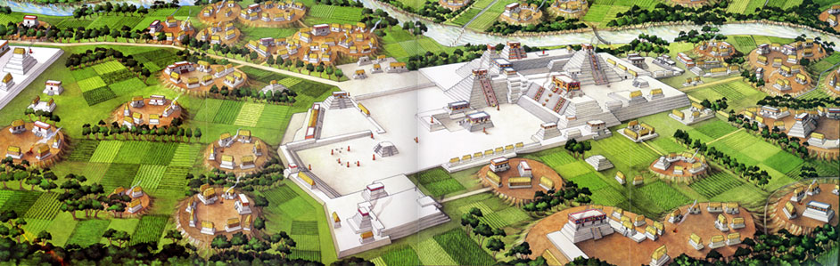
  1. Plan of the City of Copán (from Splendours)

    This artist's rendering of the city of Copán clearly demonstrates that Mesoamerican political, economic, and religious organization was centered around the ceremonial city center. City-states, each with a capital city as its power base, were established throughout Mesoamerica. Some were collectively ruled under one dominant city-state, such as Tenochtitlán for the Aztec Empire.

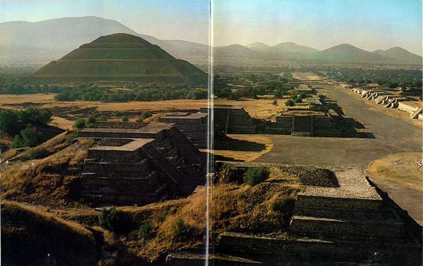
    Several pyramid-temples, a signature feature of Mesoamerican architecture, are shown in the plan. Sunrise and sunset, the movements of the constellations, and the appearance and disappearance of the moon, Venus, and other planets and stars determined the orientation of the pyramids and their relation to other structures. The structures themselves were built according to established patterns of religion and were harmonized with the calendar, which was itself closely tied to religion. For example, in Teotihuacán two stairways of the Pyramid of the Sun each have 182 steps, for a total of 364 steps, plus the platform, to represent the 365 days of the solar calendar.

    Surrounding the ceremonial center are fields of crops serving as the agricultural base for the area. Corn, beans, and squash formed the foundation of agriculture in Mesoamerica. Peppers, potatoes, sweet potatoes, tomatoes, cacao (chocolate), peanuts, beans, squash, avocado, vanilla, and many fruits such as pineapple, papaw, and mango, were also cultivated.

Back Next